
Map of El Pueblo
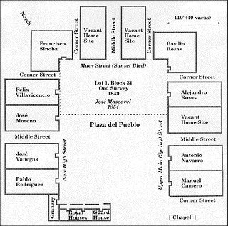
Reproduction of Argüello’s 1786 map of the town plan, translated into English, with the founding 11 families’ and 44 settlers’ homes. The plaza and residences appear in the top-left and the agricultural fields in the bottom-right. The two streams running from top to bottom are the zanja, an irrigation ditch, and the river. El Camino real, the road connected the pueblo to the San Gabriel Mission and other Spanish settlements, runs left-to-right between the plaza and the farmland. This map is thought to be of land 1.6 miles away from Azusa Street at El Pueblo de Los Angeles Historic Monument and that settlers used the land at present-day Azusa street.