
The Chumash people
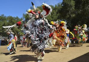
The Chumash and Gabrielino-Tongva peoples were the first human inhabitants of the Channel Islands and Santa Monica Mountains areas. They are known to have lived here for thousands of years and are believed to first come to the area in 30,000 b.c.; numerous archaeological sites have been uncovered in the past decade. The Chumash and Gabrielino-Tongva peoples visited present-day Azusa Street and downtown Los Angeles regularly to visit the Los Angeles river, however, they are not thought to have established a village in the area because the Los Angeles River flooded the valley regularly prior to being altered by future settlers.
There were about 20,000 Chumash living in an area that covered California’s coast from Malibu in the South, to San Luis Obispo in the North. The successful livelihood of the Chumash people was based upon their subsistence upon the available natural resources – plants, animals and fish, and their sustainable ways of utilizing these resources. They found use for almost every type of plant and animal available – for food, clothing, medicine and tools. Their environment inspired their art (Chumash rock and cave art still exists today), their beliefs, stories, ceremonies and songs. The rich history and lifeways of the Chumash people is preserved in those art forms, which were passed down to the children of each generation.
The Chumash were a maritime culture, known as hunters and gatherers. Their boats – canoes, called tomols, enabled them to fish and trade, traveling up and down the coast to other villages. Tomols were usually constructed from redwood logs. The Chumash were not dependent upon farming, as were other Native American tribes. Acorns, seeds, bulbs, roots and nuts were abundant, as were wild game, including bears, seals, otters, shellfish, deer and rabbits.
Chumash homes were called aps, and were constructed of local plant materials. Baskets and mats were woven, and bones and plants were used for tools and clothing. The Chumash were extremely innovative and resourceful, and found uses for everything that was available, including each part of almost every plant.
The Chumash also developed a variety of games, which were designed to teach the young about sportsmanship and skills useful for hunting and making crafts. Stories were told to teach the children about their relationship with nature, and their cultural and religious beliefs.
The Chumash culture was one of the most unique and advanced in the continent, and there is much to learn from a people who understood the relationship between humankind and earth’s natural resources; they both feared and respected the natural world, for they knew their lives depended on it for survival.
The Tongva and Yaanga village
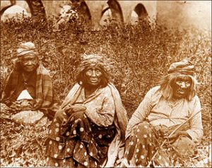
The Tongva are those Native Americans who inhabited the Los Angeles Basin and the Southern Channel Islands, an area covering approximately 4,000 square miles. There are 31 known sites believed to have been Tongva villages, each having had as many as 400 to 500 huts. Yaanga village was one of the largest and was located in present-day Los Angeles, along the Los Angeles river, which is a few blocks from where you are standing now.
Along with the neighboring Chumash, the Tongva were the most powerful indigenous people to inhabit Southern California. The Tongva are also known as the Gabrieleño, Fernandeño, and Nicoleño —Europeanized names that were assigned to the Tongva after Spanish colonization. Gabrieleño and Fernandeño are derived from the names of Spanish missions built on or near the tribes’ territory—Mission San Gabriel Arcángel and Mission San Fernando Rey de España, respectively—while Nicoleño is derived from San Nicolas Island. At the time of European contact, they may have numbered 5,000 to 10,000.
The Tongva believed in a supreme being that brought order to the chaotic world by setting it upon the shoulders of seven giants made for that purpose. The Supreme Being went on to make animals, man, and woman. The Tongva believed that humans originated in the north where the Supreme Being lived and that the Supreme Being himself led Tongva ancestors to Southern California. The Tongva did not believe in evil spirits or any concept of a hell or devil until Spanish missionaries introduced these ideas. Porpoises and owls were highly esteemed and were never killed. The practice of medicine and healing was the responsibility of the medicine man.
Tongva communities and culture fell into a rapid decline with the arrival of the Mission de San Gabriel in 1771. Many of the Tongva joined the mission (and the Missions San Fernando and San Juan Capistrano) and, upon their conversions, were compelled to abandon their villages and culture. It was their association with the Mission San Gabriel that gave the Tongva their Europeanized name Gabrielino. By the time the first American settlers arrival in the Los Angeles area in 1841, Tongva survivors were scattered and working at subsistence level on Mexican land grants. Disease further decimated the Tongva population. Today, it is estimated that a few hundred to a few thousand Tongva still live in California.
El Aliso del Viento, the historical landmark of the Tongva people
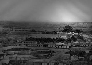
El Aliso del Viento sprang from the ground near the western bank of the Los Angeles River in the late fifteenth century — in an ominous coincidence, about the same time Columbus arrived in the Americas. Growing about one mile from Azusa Street on the other side of the L.A. River, the tree cut an imposing figure. It measured 60 feet tall and 22 feet around the trunk. Its canopy spread nearly 200 feet from tip to tip. Each year, the tree repeated its cycles—casting off leaves, resprouting them, dropping seeds, and stretching out ever so slightly—even as the surrounding landscape morphed from fertile flood plain into gritty city center. As it matured, the sycamore — located at the juncture of the Los Angeles coastal plain and the San Fernando and San Gabriel valleys — became a gathering place for Los Angeles’ indigenous Tongva people. Local leaders traveled from their villages across Southern California to confer under the shade of the tree’s canopy.
The sprawling sycamore gained almost totemic significance. In a landscape virtually free of permanent structures, the towering tree would have been visible for a great distance, and in the summer heat it would have provided welcome relief from the sun. The Tongva reportedly reckoned distances in relation to the tree, and traders from as far away as present-day Yuma knew the tree as a landmark. By the mid-eighteenth century, the mighty sycamore stood at the center of one of the largest Tongva villages, Yaanga.
The tree continued to grow in height and breadth as Spain colonized the region and radically transformed life in the village under the sycamore’s boughs. Impervious to the political and cultural whirlwind surrounding it, the tree acquired a new, Castilian name: El Aliso. (“Aliso” typically refers to an alder tree, but in Alta California it was often mistakenly applied to sycamores, as well.) In 1781, Spain founded a new agricultural settlement within a stone’s throw of El Aliso: El Pueblo de la Reina de Los Angeles.
Early Angelenos depended on the inhabitants of Yaanga for manual labor and for hand-made goods. But Spanish colonization soon devastated the Tongva village. Many residents were drawn to the nearby Mission San Gabriel Arcangel, where missionaries imposed Spanish culture upon those who converted. Those who remained in Yaanga lived under the increasingly dominant sway of the pueblo, which slowly encroached on the village. By the 1830s, El Aliso had ceased to function as the symbolic center of daily Tongva life as Yaanga changed locations twice before dissolving into historical oblivion.
El Camino Real
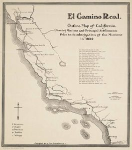
“El Camino Real,” or The Royal Highway, is the 600-mile California Mission Trail. The highway was established by the first two Spanish exploratory expeditions of the region, being the Portola expedition of 1769 and the Juan Bautista de Anza expedition of 1775. El Camino Real came by present day downtown Los Angeles to connect Mission San Gabriel Arcángel to the other 20 Alta California’s missions. The highway is still being used today, as parts of the 600-mile trail have become paved highways.
El Pueblo de la Reina de Los Angeles established
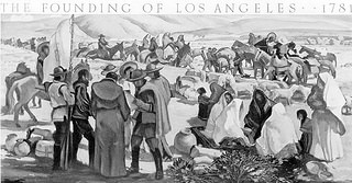
On September 4, 1781, a group of 44 settlers founded El Pueblo de la Reina de Los Angeles (“The Town of the Queen of Angels”). The pueblo flourished and, by the late 1840s, Los Angeles was the largest town in California. The center of the city lay a little to the north of the present Downtown, in the area we now call El Pueblo. El Pueblo de Los Angeles Historic Monument is located at 125 Paseo De La Plaza, Los Angeles, CA 90012, which is 1.6 miles away from Azusa Street. It is thought that present-day Azusa Street was a part of the outskirts of El Pueblo de la Reina de Los Angeles. Over time, this name became shortened to El Pueblo de Los Angeles, and then to Los Angeles.
Los Pobladores: Founding Families of El Pueblo
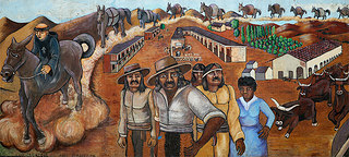
Settling 1.6 miles away from Azusa Street to found present-day Los Angeles, the eleven families that established El Pueblo de la Reina de Los Angeles were:
VANEGAS José Vanegas came from Real de Bolaños, Jalisco, and his wife, Maria Máxima Aguilar came from Rosario, Sinaloa. In 1788 José Vanegas became the first alcalde (mayor) of Los Angeles and served until 1789. He served a second term in 1796. He later became mayordomo (foreman) of Mission San Luis Rey. Their infant son, Cosme, owned Carpinteria Rancho in 1833. As alcalde, he served as both mayor and judge.
QUINTERO Luis Quíntero came from Guadalajara, Jalisco, and his wife, Petra Rubio came from Alamos, Sonora. The Quíntero family moved to Santa Barbara, where their daughters lived and were married to soldiers of the presidio. Luís Quíntero was the tailor for Santa Barbara for many years.
RODRIGUEZ Pablo Rodríguez came from Real de Santa Rosa, Jalisco, and his wife, María Rosalía Noriega came from Rosario, Sinaloa. The family moved to San Luis Rey and San Diego in 1796 as Pablo Rodríguez became the mayordomo (foreman) of these missions.
MESA Antonio Mesa came from Alamos, Sonora as did his wife, Gertrudis Lopez. Dissatisfied with farming life in Los Angeles, the Mesa family requested a return to their home in Alamos where Antonio Mesa worked in the silver mines.
NAVARRO José Antonio Navarro came from Rosario, Sinaloa, as did his wife, Regina Dorotea Soto. Although Navarro was transferred to Monterey and San Francisco for bad conduct, some of his children remained in the pueblo.
ROSAS Basílio Rosas came from Nombre de Díos, Durango, and his wife Manuela Hernandez came from Rosario, Sinaloa. At age 62, Rosas was the eldest of the pobladores. The Rosas family brought seven children with them. Two sons, Carlos and Máximo, married Indian women from nearby Gabrielino villages.
ROSAS Alejandro Rosas, son of Basilio Rosas and Manuela Hernandez, married Juana Rodriguez at San Blas, Sinaloa while on route to Los Angeles. Juana Rodriguez died in 1788, and Alejandro Rosas followed her a month later, in 1789. The grandparents, Basilio and Manuela Rosas cared for their two children.
CAMERO Manuel Camero came from Acaponeta, Nayarit, and Tomasa García came from Rosario, Sinaloa. The Cameros were childless, but later adopted two Indian orphans from Los Angeles. Manuel Camero died in 1819, while Tomasa García survived until 1844.
VILLAVICENCIO Feliz Villavicencio was from the city of Chihuahua, and his wife, María de los Santos Flores was from Batopilas, Chihuahua. The family moved to Santa Barbara in 1797, where their adopted daughter, Josefa Peñuelas, had married a soldier.
LARA José de Velasco Lara came from Cádiz, Spain, and his wife, María Antonia Campos came from Cosala, Sinaloa. As one of the three families who requested release from the pueblo of Los Angeles, Lara became mayordomo (foreman) for San Antonio Mission. Lara was sent back to central Mexico to his first wife, however, when it was discovered that she was still alive. María Antonia Campos later married a soldier, Luis Lugo. Several children surnamed Lara later lived in Santa Barbara.
MORENO José Moreno came from Rosarío, Sinaloa, as did his wife, María Guadalupe Pérez. José and María were married on September 18, 1780, just before they began their long journey to found Los Angeles. The Moreno family was successful in farming in Los Angeles and lived in the pueblo for many years. José Moreno died in 1809, while Guadalupe Pérez survived until 1860, dying at the age of about 100, becoming the last of the original adult pobladores to die.
The Zanja Madre
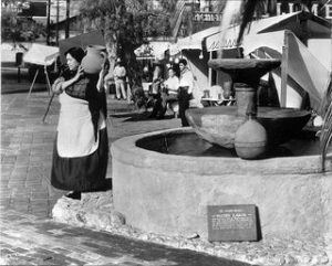
The Zanja Madre (Mother Ditch) is the original aqueduct that brought water to the Pueblo de Los Angeles from the Rio Porciuncula (Los Angeles River). It was originally an open, earthen ditch that was completed by community laborers within a month of founding the pueblo in 1781.
The Zanja Madre system ran from the Los Angeles River for more than a mile to La Placita, where the Olvera Street marketplace is now. Residents not only got their drinking water from the ditch, but its water also irrigated the surrounding vineyards and farmland. On the left, a image shows a woman carrying a jug of water from the Zanja Madre at La Placita’s well.
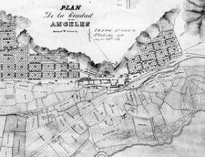
Map of El Pueblo
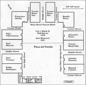
Reproduction of Argüello’s 1786 map of the town plan, translated into English, with the founding 11 families’ and 44 settlers’ homes. The plaza and residences appear in the top-left and the agricultural fields in the bottom-right. The two streams running from top to bottom are the zanja, an irrigation ditch, and the river. El Camino real, the road connected the pueblo to the San Gabriel Mission and other Spanish settlements, runs left-to-right between the plaza and the farmland. This map is thought to be of land 1.6 miles away from Azusa Street at El Pueblo de Los Angeles Historic Monument and that settlers used the land at present-day Azusa street.
Mission San Gabriel Arcángel
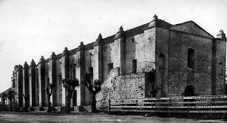
Founded by Fathers Pedro Benito Cambón and Angel Fernandez Somera y Balbuena in 1771, the mission was originally established along the slopes of the Montebello hills at the native site of Shevaanga, overlooking the San Gabriel Valley. In 1775 the mission was relocated to the native site of Iisanchanga about three miles to the northwest, where it currently stands being about nine miles east of Azusa Street.
Within fifteen years of its founding San Gabriel had 1,000 neophytes, or newly converted believers. The highest population recorded was 1,701, in 1817. Well over 25,000 baptisms were conducted at San Gabriel between 1771 and 1834, making it the most prolific in the mission chain.
San Gabriel had the largest vineyard in Spanish California and was the botanical source of many of the vines planted in the other missions in the chain. Starting with only 128 animals in 1772, the mission herd reached 42,350, primarily cattle (25,000) and sheep (15,000) at its peak in 1829. During this time, the mission furnished food and supplies to settlements and other missions throughout California.
A majority of the Mission structures fell into ruins after it was secularized in November of 1834. The once-extensive vineyards were falling to decay, with fences broken down and animals roaming freely through it.
The Mission’s chapel functioned as a parish church for the City of San Gabriel from 1862 until 1908, when the Claretian Missionary Fathers came to San Gabriel and began the job of rebuilding and restoring the Mission. On October 1, 1987 the Whittier Narrows Earthquake damaged the property. A significant portion of the original complex has since been restored.
The dirt road, seen in the image, was part of “El Camino Real” – the 600-mile California Mission Trail connecting the former Atla California’s 21 missions. The Moorish influence of the mission is evidenced by the Buttressed walls, vaulted roof, and fortress-like appearance. The walls are original and are over four feet thick, with sections through the buttresses as much as seven feet thick.
Biddy Mason is Born
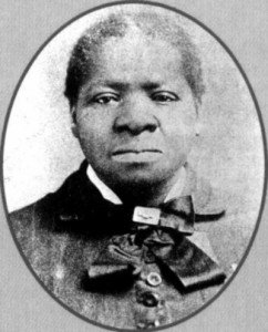
Bridget (“Biddy”) Mason was born a slave on a Mississippi plantation. When her owner, Robert M. Smith, became a Mormon convert in 1847, Mason and her three daughters joined his family on a 2,000-mile trek to the Utah Territory during which Mason was responsible for herding the cattle, preparing the meals and serving as midwife. Four years later, Smith moved his household to San Bernardino County, Calif., where Brigham Young was starting a Mormon community. California being a free state, Mason and her daughters petitioned the court for their freedom, which was granted in 1856.
Mason moved to Los Angeles where she worked as a nurse and midwife. A decade after gaining her freedom, she had saved enough to buy a site on Spring Street for $250, thereby becoming one of the first African-American women to own land in Los Angeles. In 1884, she sold part of the property for $1,500 and built a commercial building on the remaining land. Over the years, her wise business and real estate transactions enabled her to accumulate a fortune of almost $300,000. Mason gave generously to charities, visited jail inmates, and provided food and shelter for the poor of all races.
When Mason died in 1891 she was buried in an unmarked grave at Evergreen Cemetery in Boyle Heights. Nearly a century later, on March 27, 1988, in a ceremony attended by Los Angeles Mayor Tom Bradley and 3,000 members of the FAME Church, a tombstone was unveiled which marked her grave for the first time.
John Edward Hollenbeck
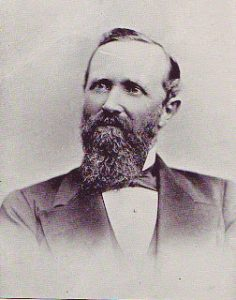
John Edward Hollenbeck was an American businessman and investor who was significantly involved in the 19th century development of downtown Los Angeles.
Arriving in Los Angeles a wealthy man from his investments in Nicaragua in 1876, Hollenbeck purchased land on the east side of the Los Angeles River, and built a large residence with broad verandas and a tower on extensive grounds on Boyle Avenue and may have owned the land that became Azusa Street. He made twenty-seven acquisitions of property by 1880. In 1884 he purchased and developed an urban business district, known as the Hollenbeck Block, within Los Angeles.
In 1878 Hollenbeck became a stockholder in the Commercial Bank of Los Angeles, located in downtown, and was elected its president. In 1881, he and other investors organized and established the First National Bank. In 1880, Hollenbeck, with former California Governor John G. Downey, horticulturalist Ozro W. Childs and other associates, persuaded the State of California to purchase 160 acres in Los Angeles to foster agriculture in the southland. The property, then known as Agriculture Park, is now known as Exposition Park, home to the Los Angeles Coliseum and the Los Angeles County Museums.
Wolfskill Ranch established
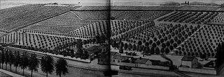
William Wolfskill, a native of Kentucky, came to California in 1831 and settled in Los Angeles in 1836, where he soon met and married Magdalena Lugo, daughter of Jose Ygnacio Lugo. In March 1838, Wolfskill purchased a 100-acre lot bounded by 3rd to 9th streets and San Pedro to Alameda streets, which he named Wolfskill Ranch, and built a large adobe (known as “Wolfskill Adobe”) located at 239 Alameda, between 3rd and 4th streets. This land is located a few blocks away from Azusa Street on the other side of the L.A. River.
In 1839, Wolfskill became a major grape producer when he planted the first vineyard of table grapes in California. Two years later, in 1841, he planted his first 2-acre plot of citrus behind his adobe, between 4th and 6th streets east of Alameda. In a short period of time, Wolfskill’s farm had increased to 28-acres of planted citrus with over 2,500 orange trees. By 1862, he owned 3/4 of all the orange trees in California and was the biggest orange grower in the United States – for which he is considered the father of early California citrus industry.
Los Angeles Becomes a City
On April 4, 1850, Los Angeles was incorporated as a municipality, five months before California achieved statehood. In 1850, the population of Los Angeles was 1,610 and the U.S. Census recorded 15 blacks, 8 Jews and 2 Chinese residing in Los Angeles County.
Early View of Los Angeles
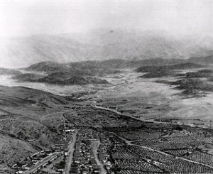
This is an old photograph of an accurate model of Los Angeles as it appeared in 1850 when Los Angeles became an incorporated city. Looking northeast, the layout of the new city can clearly be seen with the Los Angeles Plaza located in the lower left-center. The large white structure to the left of the Plaza is the Old Plaza Church. The two streets running from bottom of photo to the Plaza are Main Street on the left and Los Angeles Street on the right. Alameda Street runs from the lower right corner diagonally toward the lower center of photo. The L.A. River can be seen running from the lower-right diagonally to the center of the photo, turns left and disappears behind the mountain. At that point the Arroyo Seco can be seen at its confluence with the LA River. The tall majestic San Gabriel Mountains stand in the far background. Vineyards blanket the area between the City and the L.A. River (lower right). The large dark spot in the lower-right of the photo is El Aliso del Viento, the historic landmark of the indigenous Tongva people who once lived in the Indian Village of Yaagna at that location, adjacent to the L.A. River.
Calle de los Negros
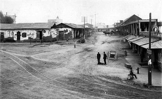
Los Angeles Street was first named in 1854. Before the first official survey of the area in 1849, most of this thoroughfare was called Calle Principal (Main Street). Other sections were known as Calle de la Zanja (Ditch Street), Calle de Los Vinas (Vineyard Street) and–much to the south–Calle de los Huertos (Orchard Street), which is now San Pedro Street. These formed the principal highway running south to the Embarcadero of San Pedro.
At its northern end, near the Plaza, a 500-foot stretch was known as Calle de Los Negros, which had a racially diverse population. One the left is a view of Calle de los Negros, one of the roughest streets in town. The tower of the Old Plaza Firehouse can be seen in the background.
Waterwheel and the Zanja Madre
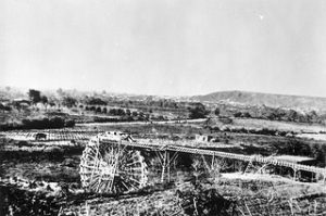
In 1857 William Dryden and his newly incorporated water company, Los Angeles Water Works Co., erected a forty foot water wheel to lift water from the Los Angeles River to the city’s main water ditch, the Zanja Madre. An image of this water wheel can be seen on the left, which was captured in 1863. Dryden constructed a large brick and wood storage tank in 1858 in La Placita, the city’s plaza which was located about one mile north of Azusa Street. It would remain there for about 10 years and then be replaced by a fountain. Afterward, water would continue to be stored in other tanks on the periphery of the plaza as well as in other nearby reservoirs.
The conversion from total dependence on the zanja system for domestic water to an underground iron pipe water system began in 1867. Jean Louis Sansevain, a Frenchman who owned an extensive vineyard and winery on Aliso Street, was authorized by the City Council to lay 5,000 feet of iron pipe and to build a dam and reservoir. Discouraged by repeated failures, Sansevain the following year offered his lease to a group of individuals who formed a private corporation known as the Los Angeles Water Company.
St. Vincent’s College for Boys
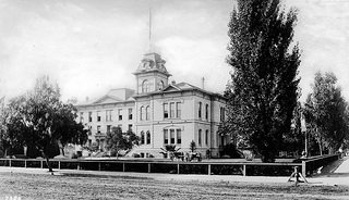
In 1865, the Vincentian Fathers were commissioned to found St. Vincent’s College for boys in Los Angeles, and appointed John Asmuth, C.M. as its first President Rector. The college was originally located in the Lugo Adobe House at the southeast corner of Alameda and Los Angeles streets. The building was one of the few two-story complexes in the city at that time and had been donated by Vicente Lugo.
Although the building no longer stands, its original site was across Alameda Street from the current Union Station on the Plaza near the southeast end of the city’s historic Olvera Street, about 1.4 miles north of Azusa Street. The campus encompassed Broadway, 6th, Hill, and 7th streets, the entire block being used for athletic fields, etc. Over time, the college moved to different locations and was renamed. The college, now Loyola University, was the first institution of higher learning in Southern California.
Sonoratown, an early neighborhood
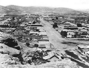
The neighborhood of “Sonoratown” acquired its name during the years of California’s gold rush, when a wave of miners and other migrants from the Mexican province of Sonora settled there.
Drawn originally to Northern California’s Gold Country, the Sonoran 49ers introduced several innovations, including the panning method, and quickly established themselves as some of the state’s most successful prospectors. Beginning in 1848, when a ban on immigration from northern Mexico was lifted, thousands of Sonorans passed through Los Angeles every year on their way to the Gold Country. Others came to work on Southern California’s vast cattle ranches, which supplied the booming northern counties with meat. In 1851 alone, approximately 8,000 Sonorans passed through Los Angeles, then a town of only 1,600.
But with the wounds of the recent Mexican War still fresh, a peaceful coexistence between the Mexican miners and their American counterparts was unlikely; by 1850, most Sonorans had been evicted from their mining claims. Many returned to Mexico, but a significant minority lingered in Southern California, where the footprint of Anglo culture was still faint. Sonoratowns quickly sprang up across the region, from Santa Barbara to San Diego. (Despite the name, Sonorans were not the only denizens of the region’s Sonoratowns; Anglo-Americans then used the terms “Sonoran” and “Mexican” interchangeably, and immigrants from East Asia, South America, and Europe also called the Sonoratowns home.)
In Los Angeles, the erstwhile miners settled in the area north of the city’s old plaza, where native, Spanish-speaking Angelenos still occupied aging adobes dating from the city’s Spanish and Mexican periods. The housing was generally either old adobe structures or “housing courts,” which were ramshackle structures built around a central area. They generally consisted of two rooms. A kitchen, typically six by 10 feet had a small wood-burning stove and a table. The other room usually had a bed and a chair. The buildings were made of pine, whitewashed on the inside and painted either brown or red on the outside, and each room had one window. There was no plumbing, and residents shared a common outhouse. Lighting was by candles.
Sonoratown became a vibrant if destitute Mexican community. Life in the house courts and crumbling adobes may not have been comfortable, but residents there preserved remnants of the city’s original Latin American culture. Among white Angeleños, meanwhile, the neighborhood developed a reputation as a rough part of town, where “every evening there was much indulgence in drinking, smoking and gambling,” as Harris Newmark put it. Cockfights were common, according to Newmark, and many saloons doubled as brothels.
In the late nineteenth century, even as white Angeleños scorned Sonoratown as a slum, tourists discovered it as a place to commune with Southern California’s Spanish past. The publication of Helen Hunt Jackson’s 1884 pastoral novel Ramona introduced Americans to a romantic reimagining of Southern California’s history. In the ensuing years, many of Jackson’s readers came to Sonoratown in search that Spanish fantasy past—never mind that most Sonoratown residents arrived after the American conquest.
J. Torrey Connor was among the pilgrims. In her 1902 travelogue, Saunterings in Summerland, Connor wrote: “Among the households of Sonoratown may still be found those who remember the days when the flag of the Mexican republic floated over the pueblo. La Senora [de la Reina de Los Angeles] is bowed beneath the weight of years, but she has not forgotten how she danced in the moonlight under the golden-fruited orange trees, to the trilling of mandolins, and well she recalls how, with a glance from her bright eyes, she brought the gay caballero to her feet.”
The image on the left is of Sonoratown in 1869.
Los Angeles’s Population in 1870
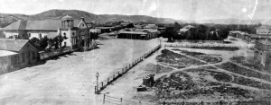
In 1870, the population of Los Angeles was 5,730. The panoramic view of ‘the Plaza’ (La Placita) and the ‘Old Plaza Church’ (Mission Nuestra Senora Reina de Los Angeles). The square main brick reservoir in the middle (partial view) was the water reservoir builit by William Dryden and his LA Water Works Co. to collect water from the ‘mother ditch’ (Zanja Madre). The image was taken in 1869.
William J. Seymour
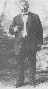
William Joseph Seymour was a minister and the prominent leader of the Azusa Street Revival, which many contribute to the birth of the Pentecostal movement. In 1972, Sidney Ahlstrom, a church historian of Yale University, stated that Seymour was “the most influential black leader in American religious history.” He was born in Centerville, Louisiana in 1870 and moved to Los Angeles in 1906, where he lived and preached until his passing in 1922.
Bible Study becomes a Church
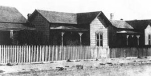
Biddy Mason establishes a bible study in her home in Los Angeles, California, that becomes Stevens African Methodist Episcopal Church and is currently know as the First African Methodist Episcopal Church. The picture on the right is an image of Biddy Mason’s home on First Street in the 1870s, which is a few block away from Azusa Street. In the late 1800s, it was common to for bible studies to form, grow, and transition into a congregation that founds a church site.
The Chinese Massacre
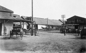
The Chinese Massacre of 1871 was a racially motivated riot on October 24, 1871 in Los Angeles, when a mob of over 500 men entered Chinatown to attack, rob and murder Chinese residents of the city. The riots took place on Calle de los Negros, which later became part of Los Angeles Street. A total of 18 Chinese immigrants were systematically killed by the mob, making the so-called “Chinatown War” the largest incident of mass lynching in American history.
Olvera Street forms
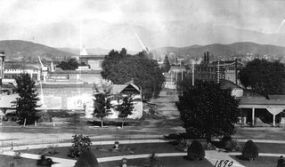
After the Mexican-American War, the Plaza remained the center of El Pueblo. A small alley branching off of the Plaza—Wine Street—had its name changed by City Council ordinance in 1877 to Olvera Street to honor Augustín Olvera, the first Superior Court Judge of Los Angeles County, who owned an adobe house nearby. Over time, Olvera Street became a marketplace, with cafes, street vendors, and shops, and still exists about one mile from Azusa Street. The image on the left shows is from 1890, looking north across the L.A. Plaza to the beginning of Olvera Street. The Olvera Adobe can be seen to the right on the northeast corner of Olvera and Marchessault streets.
The Grand Opera House
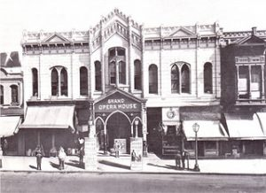
The first auditorium built in Los Angeles was the Grand Opera House, located on Main Street by First Street, just a few blocks from Azusa Street. It was built by Orzo W. Childs, had 1800 seats, and dedicated on May 24, 1884. It was first called Child’s Opera House, named after Mr. Childs. Mr. Childs was a horticulturist and one of the civil leaders who provided land to University of Southern California, which created an endowment to fund the establishment of their campus.
Los Angeles in 1877
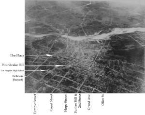
Floating some 9,000 feet above the city in a hot-air balloon in 1887, Edwin H. Husher took what may be the first aerial photo of Los Angeles.
By 1887, the City’s population had grown to over 20,000 people with most of the new development having taken place south of the original Pueblo and LA Plaza as seen in the above photo.
Aerial photo of Los Angeles looking East on June 27, 1887 taken from a balloon. Note the farmland south of Second Street and east of Main Street to the Los Angeles River. The circular form of the Plaza is visible to the center left.
312 Azusa Street Building is Constructed
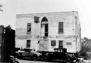
Stevens African Methodist Episcopal Church constructs a 40 feet by 60 feet church building at 312 Azusa Street. Inspired by a vision from God to establish a church that would minister to the mind, body and soul of all who would join, Biddy Mason funded the construction with her son-in-law, Charles Owens.
Flooding at 312 Azusa Street
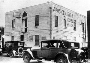
A massive flood in the late 1880s severly damages downtown Los Angeles. 312 Azusa Street home is serverly damaged and is left condemned for several years, but found new life when William James Seymour was invited to be a pastor for the newly formed Black Holiness Church at this site in 1906. Seymour opened the historic meeting in April of 1906 and the Azusa Street Revival began. The Azusa Street Revival is credited by many to be the birthsite of the Pentecostal movement. In just over 100 years, Pentecostalism has grown to have 500 million followers.
The Arcade Station
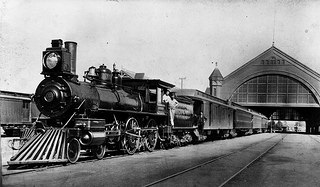
In 1887, the still-standing Wolfskill Adobe would be razed to make way for the old Southern Pacific Railroad’s Arcade Station, which was located at Fifth and Alameda and a few blocks from Azusa Street. This, too, would be demolished in 1914 and replaced with a larger and more modern railroad passenger depot – the Central Station. This station influenced business developement and population growth around the nearby Azusa Street and downtown Los Angeles.
The Arcade Station was the second station built by Southern Pacific in Los Angeles (and first one built primarily for passenger service). Built in 1889 and used until 1914 when it was replaced by larger SP Central Station. It was demolished shortly thereafter.
This image, taken in 1891, shows Southern Pacific steam engine no. 1364 heading the train at the Arcade Station at Alameda between 4th and 5th St., about one mile from Azusa Street.
Union Rescue Mission and Skid Row
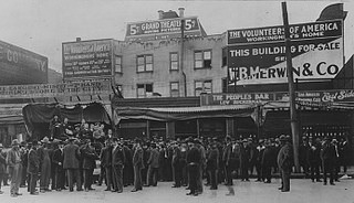
Union Rescue Mission (URM) is one of the largest missions of its kind in America — bringing help and hope to men, women, and children experiencing homelessness in Downtown Los Angeles. URM was founded in 1891 by Lyman Stewart, president and
founder of Union Oil Company. George A. Hilton served as the first superintendent of the Mission, originally known as the Pacific Gospel Union. During those early days, URM took to the streets in gospel wagons to offer food, clothing, and salvation to the less fortunate. Over the years, URM has continued and expanded its efforts to feed both the body and the soul, helping individuals and families break the cycle of poverty and achieve self-sufficiency.
This 54-block area in downtown Los Angeles became Skid Row in the late 1800s — which was when Union Rescue Mission first opened its doors. This particular area was an ideal congregating spot for hobos, aimless rail riders, transient workers, and people running away from past lives because it was the last stop on the train for the whole country. Daily rate hotels and various entertainments (mostly bars and brothels) catered to the culture of rail riders who were transient by nature.
There may be several definitions of the boundaries of Skid Row, but the one we see to be most accurate and widely accepted is 3rd and 7th Streets, to the North and South, and Alameda and Main, to the East and West, respectively. The image on the left is from 1914, showing the Union Rescue Mission’s gospel wagon distributing food at the corner of First and Los Angeles Streets.
Oil Drilling increases Population in Los Angeles
In 1865, seven years after Edwin Drake developed the first oil drilling system in North America—located in Pennsylvania—Union Matolle Company moved into California’s Central Valley, east of San Francisco. Union Matolle Company hoped to replicate the success of the Pennsylvania drillings and find large amounts of oil in Northern California. During this period, California’s population increased by approximately 375% in the years following the 1849 gold rush, and California’s demand for oil was increasing dramatically. However, Union Matolle failed to find sufficient oil supplies. The company could not produce the oil to keep up with consumer demand. As a result, Californians found themselves in desperate need of oil.
Meanwhile, in 1892, Edward L. Doheny, a gold prospector, and his partner, Charles A. Canfield, discovered an abundance of oil in Southern California. When word spread about Doheny and Canfields discoveries, drilling companies flocked to Southern California. By 1894, 80 wells were producing oil in the Los Angeles area; by 1897, the number of wells had bourgeoned to over 500. This created a lot of jobs opportunities in Los Angeles, and the population grew from 50,395 in1890 to 102,479 in 1900, according to the US Census Bureau.
The discovery of oil in California had a significant impact on the price of oil—both in the state of California and across America. In 1860, 0.5 million barrels of oil were produced throughout the country. By 1895, the state of California, alone, produced 1.2 million barrels of oil. With the new oil supplies from California—along with increased oil production in Texas and Pennsylvania—the price decreased from $9.60 per barrel in 1860 to $0.25 per barrel in 1895.
American oil companies including Union Oil Company became concerned with this development because oil prices had fallen too low for oil companies to maintain high profit margins. Union Oil Company and other oil companies lobbied local and federal governments to regulate the overproduction in the oil market. Their attempts, however, were futile and no regulation was passed. Oil prices remained around $1 through the end of the 19th century.
At the turn of the century, oil production in California continued to rise at a booming rate. In 1900, the state of California produced 4 million barrels. In 1920, production had expanded to 77 million barrels. Between 1920 and 1930, new oil fields across Southern California were being discovered with regularity including Huntington Beach in 1920, Long Beach and Santa Fe Springs in 1921, and Dominguez in 1923. Southern California had become the hotbed for oil production in the United States. In a 1926 Times magazine article, it was said, “[The Standard Oil Company of California] is the largest individual producer of crude oil in the U.S. and dominates the marketing of petroleum products along the west coast of both Americas.” During this same period, California’s agriculture and manufacturing markets were also expanding rapidly, and the increased oil production helped to power the development of these industries.
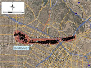
Even today, oil production is active in Los Angeles, even as close as 2 miles away from Azusa Street. The image on the left shows active oil production sites in downtown Los Angeles.
Death of El Aliso del Viento
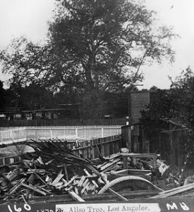
After 300 years serving as a spiritual landmark for the region, El Aliso del Viento witnessed the growth of the agricultural industry while proving shade for citrus farmer’s newly constructed home. The next owner created a winery with the surrounding land, but felt El Aliso del Viento was too big and not worth restoring to health as the centerpiece of his winery. El Aliso del Viento was chopped down in 1892, after years of neglect mirroring the changing values and spiritual practices of the people using the land. The new locals did not make a fuss, not many remembered what had El Aliso del Viento had been. The focus was on the growing metropolis and enterprises as the city doubled its population in the following ten years. The image on the left is of El Aliso del Viento in 1891, showing the poor health of a once vibrant tree with a 200 foot canopy. El Aliso del Viento was estimated to have lived about 400 years.
Andrew A. Boyle and the development of Boyle Heights
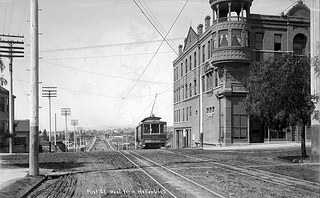
In 1858, Irish-born Andrew A. Boyle (1818–1871) came to Los Angeles from San Francisco (having also previously lived in New Orleans and Texas after his 1832 migration to America. Boyle built the first brick house east of the Los Angeles River, a few blocks from Azusa Street, and cultivated the Lopez vineyards, manufacturing and selling wine under the Paredon Blanco name. He also operated a shoe store in Los Angeles and was a member of the city council.
After Andrew Boyle’s death in early 1871, his property passed to his only daughter and her husband, William Henry Workman (1839–1918), a saddler and rising politician in town. As the first growth boom was underway in the Los Angeles area, Workman decided to subdivide part of Paredon Blanco. In Spring 1875, he partnered with banker and real estate speculator Isaias W. Hellman and John Lazzarovich, who was married to a member of the Lopez family, and announced the creation of the new neighborhood of Boyle Heights. Before long, the growth boom ended, largely because of the failure of the bank co-owned by Workman’s uncle, William Workman (1799–1876), owner of the Rancho La Puente in the eastern San Gabriel Valley. It was not until the next development boom, which took place during Workman’s tenure as mayor in the 1887-88 period, that Boyle Heights grew rapidly and became a desirable residential area for middle and upper middle class Angelenos. Some large Victorian-era homes still survive in Boyle Heights as testament to the late nineteenth-century status the neighborhood possessed. The image of the left shows displays the Boyel Hotel on the northwest corver of 1st Street at Boyle Avenue in 1895, which is one mile east of Azusa Street.
Downtown Trolleys
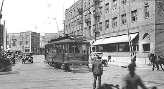
The Los Angeles Railway (also Yellow Cars, LARy, latterly Los Angeles Transit Lines) was a system of streetcars that operated in central Los Angeles and the immediate surrounding neighborhoods between 1901 and 1963. The company carried many more passengers than the Pacific Electric Railway’s ‘Red Cars’, which served a larger area of Los Angeles. The system was purchased by railroad and real estate tycoon Henry E. Huntington in 1898 and started operation in 1901 to serve the 102,479 Los Angeles residents. At its height, the system contained over 20 streetcar lines and 1,250 trolleys, most running through the core of Los Angeles and serving such nearby neighborhoods as Little Tokyo, Echo Park, Westlake, Hancock Park, Exposition Park, West Adams, the Crenshaw district, Vernon, Boyle Heights and Lincoln Heights. The image on the left is of the Los Angeles Railway’s P Line trolley crossing Alameda Street at 1st Street in Little Tokyo, a few blocks northwest of Azusa Street, as it heads for Boyle Heights in circa 1918.
Little Tokyo forms
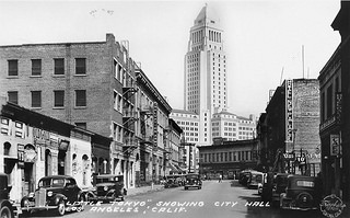
Little Tokyo traces its origins to the first business started by a Japanese seaman named Kame who opened a restaurant on Los Angeles Street, near First Street. The Japanese population grew slowly until the immigrants, known as Issei, decided they want to settle in Los Angeles and raise families. A population surge (over 30,000 Japanese came to America in 1907 alone), fueled by arranged marriages, changed Little Tokyo from a bachelor enclave into a community. Many of the local Japanese were involved in agriculture and that led to the establishment of wholesale produce markets near Little Tokyo. Despite discrimination, the Japanese built their own churches, temples and hospitals and established many business and community organizations. On the left is a view of Weller Street in Little Tokyo, looking towards City Hall, in 1938.
The Azusa Street Revival
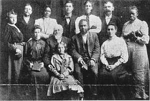
The Azusa Street Revival was a historic Pentecostal revival meeting that took place on Azusa Street in Los Angeles, California and is the origin of the Pentecostal movement. The meetings were led by William J. Seymour, an African American preacher. It began with a meeting on April 9, 1906, and continued seven days a week until roughly 1909. The revival was characterized by ecstatic spiritual experiences accompanied by miracles, dramatic worship services, speaking in tongues, and inter-racial mingling. The participants were criticized by the secular media and Christian theologians for behaviors considered to be outrageous and unorthodox, especially at the time. Today, the revival is considered by historians to be the primary catalyst for the spread of Pentecostalism in the 20th century.
Perhaps the most important legacy of Azusa Street was the renewal of the charismata (gifts of the Spirit) for the modern church. For centuries, Western churches, both Roman Catholic and Protestant, had adopted the view that the gifts of the Spirit had ceased at the end of the Apostolic Age. Known as the cessation theory, this view became especially dominant among Fundamentalists and some Holiness groups that rejected Pentecostalism. With the explosion of tongues at Azusa Street, the attention of the Church was also drawn to the other gifts of the Spirit. In addition to glossolalia, the gifts of prophecy and healing came into prominence.
Pentecostals were the first Christians since the Early Church to associate speaking in tongues with the baptism in the Holy Spirit. Before 1901, thousands of people in Holiness and Keswick groups had claimed a baptism in the Holy Spirit with various evidences to validate their experience. After 1908, Pentecostals chose the phrase initial evidenceto describe their understanding of the Pentecostal experience. This meant the other gifts of the Spirit were also evident, although tongues was the first to be manifested, as it was in the Book of Acts. Since the major text used to validate the experience was Acts 2, the Movement was given the name Pentecostal movement.
Today, there are over 500 million followers and it was significant impacted by what took place on Azusa Street between 1906 and 1909.
Decline of Old Chinatown
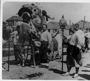
By the early 1910’s the seeds of decline were sown in Old Chinatown, which was located along Alameda Street by Olvera Street, a half mile from Azusa Street. Besides the Exclusion Acts curtailing immigration, the inducements of the new produce center at City Market, co-founded by the Chinese, and a new nearby Chinatown with an evolving residential district led to a gradual population decrease in the Old Place. Symptoms of a generally corrupt Los Angeles, news of wide open gambling houses, vestiges of opium dens, often staged for the unwary tourist, and the fierce tong warfare of the period encouraged the respectable visitor to avoid the Old Quarter. Now, highly dependent on Chinese residents alone, business in Old Chinatown declined.
Perhaps the most important factor in Old Chinatown’s increasing depression was instability and uncertainty in the actions of the landlords. With the rumors of impending City redevelopment increasing in volume with each passing year, few cared to improve or maintain their Chinatown properties. Incredibly, the historic streets of Old Chinatown east of Alameda were never to be paved as a result of this downward spiral of disinterest. Housing conditions were abominable in the end. And the Chinese became too impoverished or too dispirited to improve much. Without a place to go, they would remain stubbornly reluctant to vacate even at the very end.
The threat of Chinese relocation started as early as 1913 when a large portion of Old Chinatown was entangled in a three-way litigation suit between the Apablasa family and the City of Los Angeles over the ownership of Chinatown streets. It was contended that the streets belonged, not to the city, but to the estate since all street improvements had been paid for by the estate and the property had been maintained as private.
Meanwhile all the leases on the Chinatown property had expired and litigation was the one barrier which prevented the sale of the property for uses other than housing the Chinese. On December 12, 1913, all suits were
dropped and six acres of Old Chinatown property were sold for $310,000, possibly for Southern Pacific track ways. On November 7, 1914, a large deal was concluded for the acquisition of all Chinatown lying east of Alameda Street. This property cost the new owner L.F. Hanchett, a San Francisco capitalist, over two million dollars. Old Chinatown was to be converted into an industrial and warehouse district while a new Chinese Colony would be developed. In time, Hanchett was found to be planning a railroad terminal instead, but he was thwarted in court as his plan lost credibility.
The Hanchett experience was the first of several attempts for a terminal. Civic discussions continued at the highest levels of power, with always the favorite site being Old Chinatown since it was conveniently adjacent to a confluence of tracks and the land was controlled by one or few owners. In a day when rail was king, the strong metropolitan desire for a major rail terminal, Union Station, was akin to the push for Los Angeles International Airport years later. On the fateful day of May 19, 1931, a California Supreme Court decision was upheld approving land condemnations and the construction of the new Union Station upon the site of Old Chinatown. Two years were to slip by before an acceptable Chinese relocation proposal was accepted by the City.
Public Transit in the early 1900s
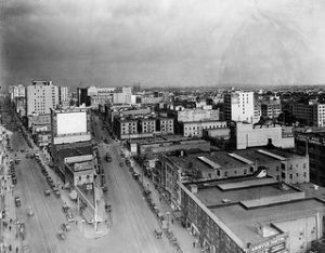
There were several public transportation options for Los Angeles residents, including trolley cars that served many neighborhoods including Little Tokyo. Elevated booths were used by the Los Angeles Railway and the Yellow Cars as a switchman’s tower to control the flow and path of streetcars through the intersection. The image on the left shows the intersection of Main Street, Spring Street, and 9th Street in downtown Los Angeles circa 1917 (2.4 miles from Azusa Street). Note the elevated kiosk at the corner. In 1920, US Census Bureau recorded that Los Angeles had a population of 576,673, growing from 319,198 in 1910. This population boom was partly due to America’s increased dependency on gasoline and the lucritive oil production industry in Los Angeles.
Immigration Act of 1924 and Little Tokyo
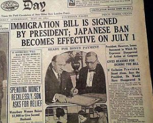
The Immigration Act of 1924 was a United States federal law that limited the annual number of immigrants who could be admitted from any country to 2% of the number of people from that country who were already living in the United States in 1890. This act halted the steady and significant growth of Little Tokyo in Los Angeles.
City Hall is Constructed and Dedicated
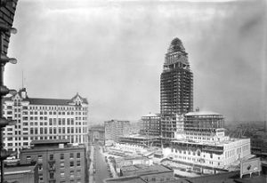
Los Angeles City Hall is the center of the government of the city of Los Angeles, California, and houses the mayor’s office and the meeting chambers and offices of the Los Angeles City Council. It is located in the Civic Center district of downtown Los Angeles in the city block bounded by Main, Temple, First, and Spring streets.
The building was designed by John Parkinson, John C. Austin, and Albert C. Martin, Sr., and was completed in 1928. Dedication ceremonies were held on April 26, 1928. It has 32 floors and, at 454 feet high, is the tallest base-isolated structure in the world, having undergone a seismic retrofit from 1998 to 2001 so that the building will sustain minimal damage and remain functional after a magnitude 8.2 earthquake. The concrete in its tower was made with sand from each of California’s 58 counties and water from its 21 historical missions. City Hall’s distinctive tower was based on the shape of the Mausoleum of Mausolus, and shows the influence of the Los Angeles Public Library, completed soon before the structure was started. An image of City Hall has been on Los Angeles Police Department badges since 1940.
To keep the City’s architecture harmonious, prior to the late 1950s the Charter of the City of Los Angeles did not permit any portion of any building other than a purely decorative tower to be more than 150 feet. Therefore, from its completion in 1928 until 1964, the City Hall was the tallest building in Los Angeles, and shared the skyline with only a few structures having decorative towers, including the Richfield Tower and the Eastern Columbia Building. City Hall has an observation deck, free to the public. The building was designated a Los Angeles Historic-Cultural Monument in 1976.
Avila Adobe
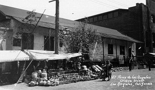
Don Francisco Avila, a wealthy cattle rancher and one-time Mayor of the pueblo of Los Angeles, built the Avila Adobe in 1818. The Avila Adobe, presently the oldest existing residence within the city limits, was one of the first town houses to share street frontage in the new Pueblo de Los Angeles.
In 1930, through the efforts of activist Christine Sterling, the Plaza-Olvera area was revived with the opening of Paseo de Los Angeles (which later became popularly known by its official street name Olvera Street). Receiving recognition, Avila Adobe is preserved as “the oldest and most historic building in Los Angeles” and Olvera Street is noted as “the first thoroughfare of Los Angeles.”
The Avila Adobe is registered as California Historical Landmark #145, while the entire historic district is both listed on the National Register of Historic Places and as a Los Angeles Historic-Cultural Monument.
The image on the left shows Olvera Street in 1929, looking across at vending booths in front of the Avila Adobe with two pedestrians walking near.
The Mexican-American Deportation and Repatriation
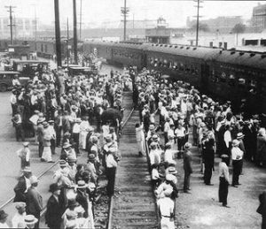
During the 1930s, tens of thousands, and possibly more than 400,000, Mexicans and Mexican-Americans were pressured — through raids and job denials — to leave the United States during the Depression after the stock market crashed in 1929. This deportation was enforced without due process.
Officials staged well-publicized raids in public places. For example, on Feb. 26, 1931, immigration officials suddenly closed off La Placita, a square near Olvera Street and about 1.4 miles north of Azusa Street, and questioned the roughly 400 people there about their legal status.
By 1930, the U.S. Census counted 1.42 million people of Mexican ancestry, and 805,535 of them were U.S. born, up from 700,541 in 1920.
The Hoover Dam powers Los Angeles
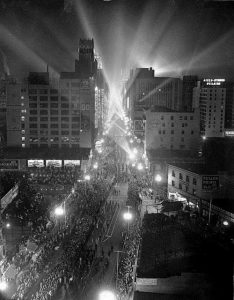
Tens of thousands of people jammed the parade route on Broadway on the night of October 9, 1936, as the street became ablaze with light when the first power streaked 266 miles from the Hoover Dam Power Plant to Los Angeles.
Hoover Dam, once known as Boulder Dam, is a concrete arch-gravity dam in the Black Canyon of the Colorado River, on the border between the U.S. states of Arizona and Nevada. It was constructed between 1931 and 1936 during the Great Depression and was dedicated on September 30, 1935, by President Franklin D. Roosevelt. Its construction was the result of a massive effort involving thousands of workers, and cost over one hundred lives. The dam was controversially named after President Herbert Hoover.
Since about 1900, the Black Canyon and nearby Boulder Canyon had been investigated for their potential to support a dam that would control floods, provide irrigation water and produce hydroelectric power. In 1928, Congress authorized the project. The winning bid to build the dam was submitted by a consortium called Six Companies, Inc., which began construction on the dam in early 1931. Such a large concrete structure had never been built before, and some of the techniques were unproven. The torrid summer weather and the lack of facilities near the site also presented difficulties. Nevertheless, Six Companies turned over the dam to the federal government on March 1, 1936, more than two years ahead of schedule.
Hoover Dam impounds Lake Mead, the largest reservoir in the United States by volume. The dam is located near Boulder City, Nevada, a municipality originally constructed for workers on the construction project, about 30 mi (48 km) southeast of Las Vegas, Nevada. The dam’s generators provide power for public and private utilities in Nevada, Arizona, and California. The Los Angeles Department of Water and Power and Southern California Edison were original authorized and managed the dam’s power plant until 1987, when the Bureau of Reclamation assumed control.
Sonoratown becomes “New Chinatown”
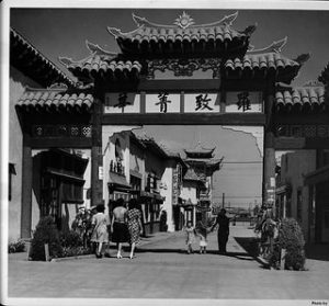
By the time novelist J. Torrey Connor sauntered down the streets of Sonoratown in the early twentieth century, market forces were already pushing the barrio to disintegration. The Southern Pacific had built its railyard and depot on the outskirts of the neighborhood, transforming Sonoratown into valuable industrial real estate. As property values rose, the district’s adobes and shacks gave way to warehouses and factories. Tourists searching for the region’s mythical past could still find it on Olvera Street—invented in 1930 by socialite Christine Sterling and Los Angeles Times publisher Harry Chandler—but the city’s actual Latin American quarter, Sonoratown, had largely been erased from the landscape.
Sonoratown’s residents found new homes. Street railways opened up the land across the river for housing, and many moved to (the original) East Los Angeles and, later, to the new subdivisions of Belvedere and City Terrace. When the district north of the plaza was rechristened New Chinatown in June 1938, its previous role as Sonoratown had already faded from the city’s collective memory.
On the sunny Saturday of June 25, 1938, California’s Governor Merriam and a host of dignitaries dedicated Los Angeles Chinatown’s Central Plaza in a gala Grand Opening ceremony. One of the Nation’s first malls and certainly the first modern American Chinatown, owned and planned from the ground up by Chinese, Central Plaza would provide a magnificent hub and lexus for growth into the famous colorful, vibrant Chinese American community we all know today.
Originally, New Chinatown consisted of many notable restaurants, shops, an herbal store, a grocery store, a bean cake factory, a Chinese deli and offices. In 1938, these long-time establishments were all moved from Los Angeles’ Old Chlnatown, not quite a mile away. What led to this sudden mass relocation into Los Angeles’ Little Italy, and the need for establishing a new Chinatown?
The first Chinese was recorded to be in Los Angeles in 1852. Continuous settlement began in 1857. By 1870, an identifiable “Chinatown” of 200 or so was situated on Calle de Los Negros – Street of the Dark Hued Ones – a short alley 50 feet wide and one block long between El Pueblo Plaza and Old Arcadia Street. These early, mostly male, Chinese were mainly laundrymen, market gardeners, agricultural and ranch workers, and road builders. Despite the heavy discrimination in the late 19th century, Chinese held a dominant economic position in the Los Angetes laundry and produce industries for several years of this period. Consequently, old Chinatown flourished, expanding eastward from the Plaza across Alameda Street and eventually attaining a population of over 3000. The Exclusion Acts inhibited any real growth for many years.
In a typical experience, Chinese became lessees, subleasees or tenants of a major land or property owner, such as Apablasa. Laws prohibited most from citizenship and hence, property ownership. The Chinese densely settled a major part of Old Chinatown on the Juan Apablasa grazing grounds and vineyards, controlled by his old widow. Inability to gain ownership in large measure would have dire consequences later.
Old Chinatown in its heyday, 1890 to 1910, could count 15 or so streets and alleys, and perhaps 200 building units. It had sufficient size and sophistication to boast of a Chinese opera theater, three temples, a newspaper (for a while), and later, its own telephone exchange. Old Chinatown was a residential as well as commercial community. The slow increase in the number of women would lead to the establishment of families with children. During this time, most of today’s leading Chinese family and district associations, Chinatown institutions were founded, and church missions were organized, which began the process of community acculturation. Old Chinatown, with restaurants, curio shops, and “strange” entertainments, even became an attraction for the early, pioneering breed of American tourist.
Executive Order 9066 and the WCCA
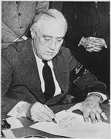
Executive Order 9066, signed by Franklin D. Roosevelt on February 19, 1942, authorized the removal of all persons of Japanese ancestry from the West Coast by authorized military commanders to designated military areas, however, it was signed before there were any fully constructed sites to house the displaced Japanese Americans. After the voluntary evacuation program failed to entice many families to leave the exclusion zone, the military took charge of the now-mandatory evacuation. On April 9, 1942, the Wartime Civilian Control Administration (WCCA) was established to coordinate the forced-removal of Japanese Americans to inland concentration camps, also known as internment camps. This order had a profound impact on Little Tokyo in Los Angeles, as this neighborhood had and still fosters one of the largest Japanese populations in America.
“Assembly Centers” in Little Tokyo
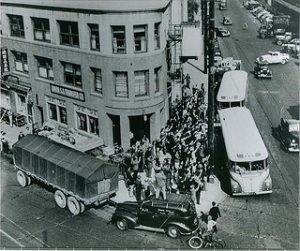
With the outbreak of the Pacific War, all people of Japanese descent living on the West Coast were removed from their homes and incarcerated, subject to mass removal and incarceration. To prove their loyalty, many American-born men served in the army or military intelligence service. Their heroic contributions helped the Nisei to break through racial barriers and gain rapid social mobility after the war. The image on the left is of the Nishi Hongwanji Buddhist Temple in Los Angeles’ Little Tokyo (currently the Historic Building of the Japanese American National Museum), which became a roundup point for the Japanese Americans who were sent to “assembly centers” in 1942. These “assembly centers” booked and transported all people of Japanese descent to internment camps.
Japanese Americans Forced to Move to Internment Camps
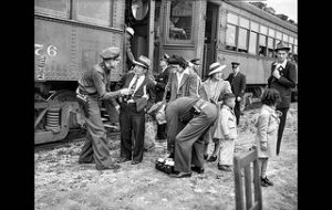
A total of 92,193 Japanese Americans were transferred to these temporary detention centers from March to August 1942. Many Japanese Americans who resided in Los Angeles lived in Little Tokyo and were forced to relocate to Manzanar and Tule Lake, losing their homes, businesses, belongings and freedom. The image on the left is of Los Angeles residents getting on the Pacific Electric train at the Santa Anita Park, which became an “assembly center” for Japanese Americans forced to relocate to internment camps. The photograph was taken on April 3, 1942.
All but four of the 15 internment camps (12 in California, and one each in Washington, Oregon and Arizona) had previously been racetracks or fairgrounds. The stables and livestock areas were cleaned out and hastily converted to living quarters for families of up to six, while wood and tarpaper barracks were constructed for additional housing and communal latrines, laundry facilities and mess halls.
LA in the 1950s
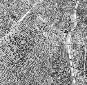
Ariel image of downtown Los Angeles in 1952, showing homes of some of the 1,970,358 residents.
Olvera Street gains Historic Landmark status
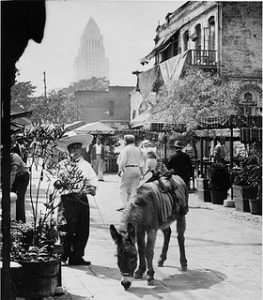
During the 1920s, the pace of Mexican immigration into the state increased rapidly. California was a primary destination with Los Angeles being a common choice. As a part of a movement that sought to preserve what was then seen as California’s “authentic” heritage, resident Christine Sterling began a public campaign to renovate Francisco Avila Adobe, which evolved into a campaign “to preserve and present the customs and trades of early California” at Olvera Street through sustaining the Mexican marketplace which had been thriving since the 1880s. The campaign was embraced and Olvera Street gained California State Historic Landmark status in 1953. Today, many of the merchants on Olvera Street are descended from the original vendors.
Eviction of Chavez Ravine Residents
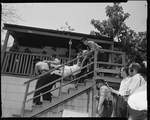
The fight to preserve affordable housing and prevent displacement is a historic one in Los Angeles, as it is across the nation. One of the most famous stories is that of the residents of the communities of Palo Verde, La Loma, and Bishop that made up Chavez Ravine, which is located 2.5 miles north of Azusa Street.
This tight-knit Mexican-American community near downtown was promised new and modern low-cost housing would be built on their land. The Housing Authority then issued eviction notices to the Chavez Ravine residents, promising the families that they would have first choice of the new housing once the development was completed. The Chavez Ravine residents who sold their property to the Housing Authority soon discovered that they had limited choices of where to relocate. Many residents chose instead to ignore the eviction notices and squat on their own property.
It was a time when the public was fed a steady diet of red baiting and racism as the House on Un-American Activities waged a destructive war on civil rights. The LA business power structure didn’t care for the idea of spending millions on developing real estate for poor people only to give it back to them for a pittance. The city purchased the land at a huge discount in 1949. The single stipulation to the agreement was that the land had to be used for the good of the public.
In 1958 LA voters passed Proposition B, which gave the land to the Brooklyn Dodgers who were relocating to Los Angeles. On May 8, 1959 the LAPD arrested the remaining residents in Chavez Ravine, forcibly dragging many from their homes. Bulldozers began flattening every structure in their path. On April 10, 1962 the Dodgers played their inaugural game at the new stadium in Chavez Ravine.
The photograph on the left shows Los Angeles County Sheriffs forcibly evicting Mrs. Aurora Vargas, 36, from her home at 1771 Malvina Avenue in Chavez Ravine, which was 2.5 miles north of Azusa Street.
The East Los Angeles Interchange
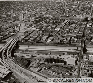
Considered on of the largest interchange of freeways in the world, this interchange connects the Golden Gate Freeway, Santa Ana, Santa Monica Freeway, San Bernadino and Pomona freeways and is located about one mile northeast of Azusa Street.
Department of Water and Power Building is completed
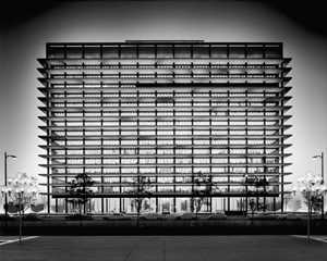
Located less than one mile north of Azusa Street, one of the most iconic buildings in downtown Los Angeles was built and completed in 1965. Designed by A.C. Martin architects, the Department of Water and Power Building, also known as the John Ferraro Building, has left it’s mark on the visual aesthetic of downtown.
Closing of Angel’s Flight
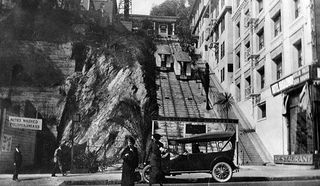
Angel’s Flight railway was credited as “the world’s shortest railway” and was 2 street blocks long. It was located less than two miles northwest of Azusa Street and assisted residents traveling up the steep 33% incline of Bunker Hill. The railway closed on Bunker Hill to make way for the massive redevelopment project in the Bunker Hill region of Downtown. It was designated as Los Angeles Historic-Cultural Monument in 1962 before it was dismantled.
LA in the 1970s
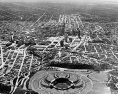
In the 1970s, the population in Los Angeles was 2,816,061. The image on the left shows downtown Los Angeles and Dodgers Stadium, taken in 1970s. US Census Bureau charted steady growth in Los Angeles from the 1930s to the 1970s, with 350,000-400,000 new residents every ten years.
Redevelopment Plan of 1975 and Skid Row
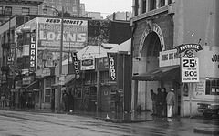
As development began and industrial markets grew — particularly the flower and fashion districts adjacent to Skid Row — the need to “improve” Skid Row arose. Various groups consistently initiated efforts to improve the community.
In 1975, a Redevelopment Plan was adopted, which included a “Policy of Containment.” This policy concentrated social service agencies and people experiencing homelessness in one section of the city, where many of them naturally congregated. The goal of the policy was to stabilize and centralize the area to make services more accessible, not to crowd the area with people experiencing homelessness or fence them in.
Since 1975, there have been improvements in Skid Row in terms of services for people experiencing homelessness. Two parks in the area have been rehabilitated, nonprofit-owned SROs have moved into the area, and many service facilities have been renovated and/or relocated.
In addition to infrastructure redevelopment, service providers are recognizing a need to rehabilitate people — rather than just providing meals and beds. Several shelters — including Union Rescue Mission — provide 24-hour services (rather than overnight only), rehabilitation programs, and a safe place for people during the day.
There may be several definition of the boundaries of Skid Row, but the one we see to be most accurate and widely accepted is 3rd and 7th Streets, to the North and South, and Alameda and Main, to the East and West, respectively.The image on the left is of the 200 block on East 5th Street in the 1970s.
Japanese American Cultural and Community Center is Established
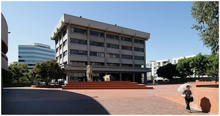
Located in Little Tokyo, the historic heart of the Japanese American community, the JACCC was the dream of visionary Issei and Nisei (first and second-generation) Japanese American pioneers to create a permanent center for the community where arts and culture come alive and can flourish for future generations.
The JACCC has its roots in the early 1970’s redevelopment of Little Tokyo, when a citizens advisory committee determined that one of its first priorities was to build a cultural and community center. With the support of the Community Redevelopment Agency (CRA) of Los Angeles and other lead funders, the JACCC’s Center Building was opened in 1980. This was followed shortly thereafter by the opening of the Japan America Theatre and JACCC Plaza, respectively, in 1983.
Construction on the JACCC’s facilities took place between 1978 and 1983 at a cost of approximately $15 million. The initial capital campaign to build the JACCC was launched in 1976 and largely completed by 1983 with the participation of the Japanese American community, local governmental sources, U.S. foundations and corporations, and Japanese businesses, both in the U.S. and Japan. A final push to retire the remaining building debt of approximately $1 million was completed in 1989.
The Civil Liberties Act of 1988

In the 1980s, the third-generation youth joined the Nisei in seeking redress for the injustices suffered by the internees during the war. The lengthy struggle ended in the passage of the Civil Liberties Act, additionally known as the Redress Law. The Civil Liberties Act of 1988 granted reparations to Japanese Americans who had been interned by the United States government during World War II. The act granted each surviving internee about $20,000 in compensation, with payments beginning in 1990. The legislation stated that government actions were based on “race prejudice, war hysteria, and a failure of political leadership” as opposed to legitimate security reasons. A total of 82,219 received redress checks, including residents of Little Tokyo.
Japanese American National Museum Opens
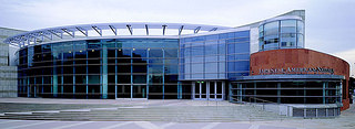
Located on N. Central Ave. and E. 1st Street, the Japanese American National Museum opened in 1992 with the mission to promote understanding and appreciation of America’s ethnic and cultural diversity by sharing the Japanese American experience.
Built by Japanese immigrants in 1925, the Japanese American National Museum’s renovated historic building was the first structure designed specifically in Los Angeles to house a Buddhist place of worship, the Nishi Hongwanji Buddhist Temple. It is located less than a mile from Azusa Street, walking west along 1st Street.
The Japanese American National Museum is the first museum in the United States dedicated to sharing the experience of Americans of Japanese ancestry as an integral part of U.S. history. Through its comprehensive collection of Japanese American objects, images and documents, as well as multi-faceted exhibitions, educational programs, documentaries and publications, the National Museum shares the Japanese American story with a national and international audience. At this time, Los Angeles had 3,485,499 residents.
Grapefruit Planting Ceremony on Azusa and San Pedro Streets
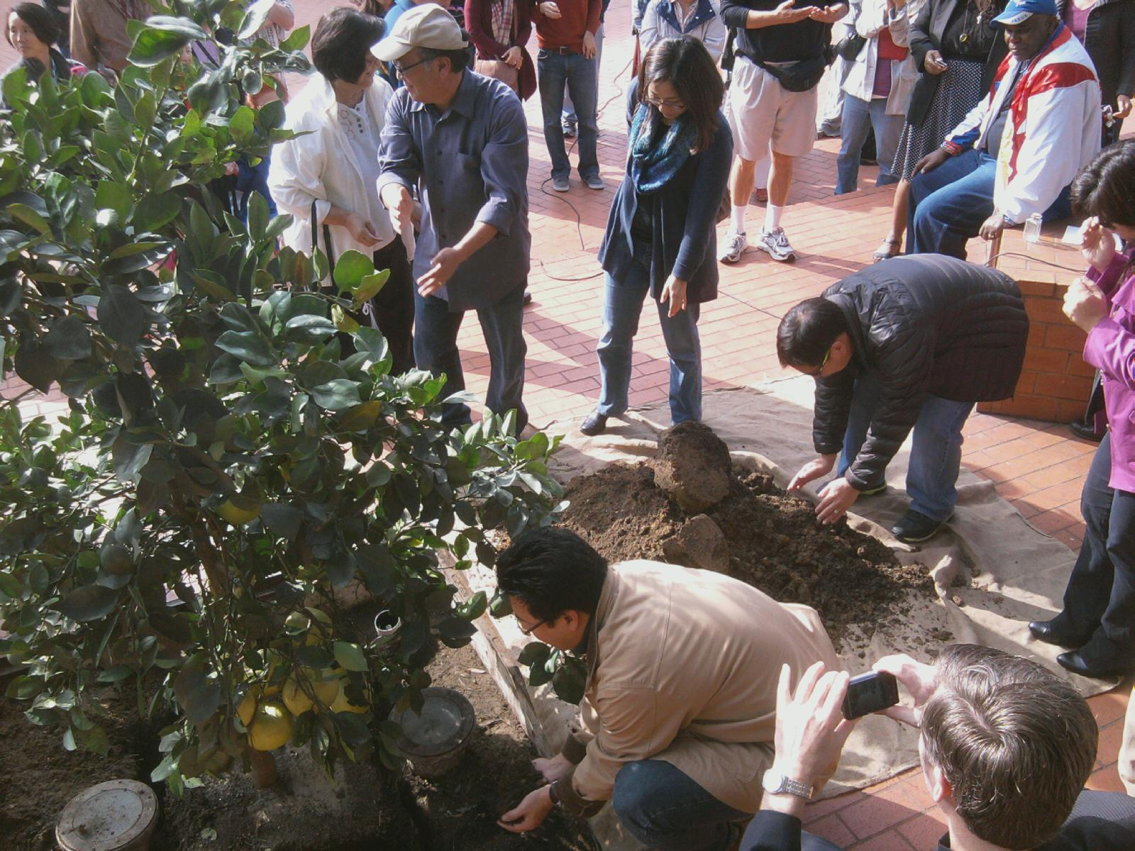
On December 8, 2012 at the corner of Azusa and San Pedro, several community groups came together to plant a grapefruit tree to replace one that had been lost. Japanese Americans, Skid Row community activist, Native Americans, Azusa Street Revival members and Pentecostals came together to celebrate this new tree together, inviting everyone to participate by adding a scoop of soil to the newly planted tree.
In 2004, the last remaining tree from when the site was a fruit orchard was accidently killed with hot cooking oil. It was a 125-year-old grapefruit tree, which still bore fruit and was beloved by the local communities. This planting ceremony marks an important time of community-building and community-bridging along Azusa Street. At this time, Los Angeles had 3,857,799 residents.